
If you own raw land or you’re thinking about buying some, you’ve probably heard that a survey can boost its value. That’s true, but only if you know which survey to get and what to actually do with it afterward. Let’s break it down simply.
1. SURVEYS
A survey is often the first step — it defines exactly what you own and reveals any issues that could cloud title or deter buyers.
Types of Surveys
Boundary Survey
- Establishes the exact legal boundaries of your parcel
- Places physical monuments (iron pins, concrete markers) at corners
- Resolves any encroachments from neighbors or adjacent roads
- Required by most title companies and lenders before closing
- Cost: $500–$2,500 for a typical rural parcel
Wouldn’t parcel already have a boundary survey done since I am buying it?
When an existing survey is sufficient:
- The parcel has clearly defined, uncontested boundaries
- The survey is recent (typically within 5–10 years)
- No changes have been made to adjacent roads, neighboring lots, or easements since it was done
- Your buyer/lender accepts it as-is
When you’ll likely need a new or updated survey:
- The existing survey is old — legal standards and technology have changed, and an outdated survey raises red flags for buyers and title companies
- The parcel has never been formally platted (common with rural land that was carved off a larger family tract generations ago)
- Boundary disputes exist with a neighbor — iron pins may be missing, moved, or disputed
- You’re subdividing — the existing survey covers the whole parcel, not the new individual lots you’re creating
- The legal description is vague — old deeds sometimes use descriptions like “beginning at the large oak tree” which are legally problematic
- An ALTA survey is required — lenders on commercial deals almost always require this more comprehensive version regardless of what exists
Summary about Boundary survey improvement:
A boundary survey is probably the least impactful improvement you can make as a value-add strategy, precisely because you’re right — it often already exists. The real money is made in perc tests, wetland delineations, rezoning, and entitlements — things that either don’t exist yet or require active effort to obtain. Those are the improvements worth focusing on.
Topographic Survey (Topo)
- Maps elevation changes, slopes, drainage patterns, and contours across the land
- Essential for developers to determine buildable areas and grading costs
- Reveals flood-prone areas, natural drainage channels, and steep terrain
- Dramatically reduces a developer’s due diligence time and risk
- Cost: $1,500–$10,000+ depending on acreage
When Is a Topo Survey Actually Needed?
NOT needed for every parcel. Here’s the breakdown:
Rarely or Never Needed:
- Flat, featureless rural land with obvious drainage (open farmland in the Midwest, for example)
- Land being sold purely for agricultural or recreational use where a developer isn’t the likely buyer
- Very small parcels where terrain is visually obvious and simple
- Land where the buyer intends to do their own due diligence before development
Highly Valuable or Required:
- Any parcel being marketed to a developer or builder — this is the core use case
- Sloped or rolling terrain — buyers can’t assess buildable area without it
- Land near water — streams, ponds, or tidal areas where drainage and flood risk matter
- Parcels with significant elevation changes — hills, ravines, or varied topography
- Land being subdivided — engineers need it to design roads, lots, and drainage systems
- Commercial development sites — required for site plan engineering
- Parcels where floodplain is a question — a topo combined with FEMA data reveals exactly what’s in and out of the flood zone
- Large acreage tracts — terrain complexity increases with size
The Core Problem a Topo Solves for Buyers
When a developer or builder looks at raw land, their biggest unknown costs are:
- Grading — how much dirt needs to be moved, cut, or filled
- Drainage infrastructure — where stormwater goes and what it costs to manage
- Buildable yield — how many lots or buildings actually fit after accounting for slopes, drainage, and setbacks
- Road design — what grades roads need to follow and how expensive they’ll be to build
Without a topo, all of these are guesses. A developer has to either spend money doing their own survey during due diligence, or they pad their offer price downward to account for the unknown risk.
With a topo in hand, you’ve eliminated that uncertainty — and developers will pay more because their risk is lower and their due diligence timeline is shorter.
What is good or bad topo survey?
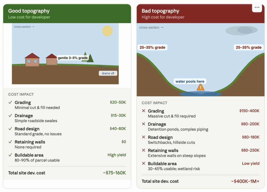
The good parcel has a consistent, gentle slope — water flows naturally downhill and off the edge of the property. A developer can lay out roads that follow the contours with minimal earthwork, and nearly every square foot is buildable. The tick marks you’d see on an actual topo drawing would be wide-spaced and evenly distributed.
The bad parcel is a bowl shape — the most problematic configuration a developer can encounter. Water from both steep sides flows toward the center and has nowhere to go. This creates three compounding problems simultaneously: the steep sides require massive grading and retaining walls, the low center creates mandatory drainage infrastructure (often a detention pond eating into your lot yield), and the wetland risk in the depression can trigger Army Corps of Engineers permits that add 6–18 months to any project.
The ticket marks on the slopes in the bad example represent how surveyors actually indicate steep grade on a topo drawing — the closer together those marks are, the steeper the terrain. A developer sees those clustered tick marks and immediately starts mentally calculating excavation costs.
The key takeaway for you as an investor: a topo survey lets you see what a developer sees before they spend a dime on due diligence. If you own the good parcel and hand a developer a topo showing gentle grades, you’ve essentially pre-answered their biggest cost questions. That certainty translates directly into a higher offer price.
How to Make Money With a Topo Survey
Strategy 1 — Buy Low, Add Topo, Sell Higher
Buy land priced low because it looks “unknown,” get the topo done, and reprice it once buyers can actually see what it offers.
This is the most straightforward approach:
- Buy a parcel with development potential that lacks a topo survey
- Commission a topo survey ($1,500–$10,000 depending on acreage)
- Remarket the property specifically to developers and builders with the topo included
- Price accordingly — the survey signals professionalism and removes risk
Example:
- Buy 50-acre tract for $300,000 ($6,000/acre)
- Spend $6,000 on a topo survey
- Relist at $340,000 — a developer sees $34,000 in savings on their own due diligence and a faster path to closing
- Net gain: ~$34,000 on a $6,000 investment
Strategy 2 — Use Topo to Prove Buildable Acreage
A 10 acre lot sounds great, but if only 4 acres are actually buildable, that number matters. Proving the usable acreage with a topo can justify a higher price than the raw acreage alone.
This is where the real money is. Many parcels are discounted because buyers assume the worst about slopes, wetlands, or drainage. A topo survey combined with analysis can prove the land is more usable than it appears.
- A wooded, hilly 100-acre tract may look unbuildable to a casual buyer
- A topo reveals that 70 of those acres are relatively flat and drain well
- You can now market 70 acres of “confirmed buildable land” rather than 100 acres of “unknown terrain”
- Developers pay per buildable acre — proving usability directly increases your price per acre
Strategy 3 — Combine Topo With a Conceptual Site Plan
Pair the survey with a simple sketch showing where a home, driveway, or septic system could go. This turns “empty land” into “land with a plan,” which buyers respond to.
This is a more advanced and very powerful move:
- Get the topo survey done
- Hire a civil engineer or land planner (often $2,000–$8,000) to create a conceptual layout showing how many lots or buildings could theoretically fit on the land
- This gives developers a “napkin deal” they can immediately evaluate
- You’re not just selling dirt — you’re selling a vision with data behind it
A conceptual site plan showing “42 single-family lots” or “180,000 sq ft of industrial warehouse” is extraordinarily compelling to developers. They can immediately run their pro forma numbers and make an offer.
Strategy 4 — Use Topo to Identify and Market a Feature
Sometimes a topo reveals a great view, a flat building pad, or a natural feature you didn’t know was there. That becomes your marketing angle.
Sometimes a topo reveals something uniquely valuable that wasn’t obvious:
- A natural ridge line with elevated views — premium for luxury residential
- A natural bowl or depression — ideal for a retention pond that can become an amenity (lake lots command 20–40% premiums)
- A natural drainage channel — can be preserved as a greenbelt or trail corridor, increasing surrounding lot values
- High ground surrounded by floodplain — the “island” of buildable land becomes more valuable when precisely defined
Strategy 5 — Floodplain Separation Play
If part of the land sits in a floodplain and part doesn’t, a topo survey can clearly separate the two. Buyable, buildable acreage sells very differently than flood-prone acreage, so this distinction alone can shift the price.
This is a sophisticated but high-return strategy:
- Buy a parcel that partially sits in a FEMA floodplain
- Commission a topo survey with precise elevation data
- Work with a surveyor or engineer to file a Letter of Map Amendment (LOMA) with FEMA removing portions of the parcel from the floodplain
- Land removed from the floodplain no longer requires flood insurance and can be developed without floodplain restrictions
- Value of that land increases dramatically — often $5,000–$20,000+ per acre just from the LOMA
The Honest Limitations
A topo survey isn’t magic. It costs money upfront, it takes time to schedule and complete, and it won’t fix a property with real problems like poor access or bad zoning. It simply gives buyers clarity, and clarity is what people pay for.
- A topo alone rarely justifies a large price increase on simple land. Flat farmland being sold to another farmer doesn’t need one — it adds cost without adding relevant information.
- It’s a supporting improvement, not a standalone value-add. Its power multiplies when combined with rezoning, entitlements, or a conceptual site plan.
- It can reveal bad news. A topo might show that drainage is worse than expected, slopes are steeper than they appeared, or that very little of the parcel is actually usable — which is useful to know before you’ve committed to a development plan, but can affect your exit price.
Bottom Line
A topo survey works because it turns uncertainty into information. Land that’s easy to understand sells faster and for more, so if you’re holding a parcel that feels hard to describe to buyers, a topo survey is often the cheapest way to change that.
| Parcel Type | Topo Value-Add Potential |
|---|---|
| Flat farmland, no development play | Low — skip it |
| Rolling/hilly land near growth | High — proves buildability |
| Land near water or floodplain | Very High — defines usable acreage |
| Large tract being subdivided | Essential — engineers require it |
| Commercial development site | Required — non-negotiable |
| Infill lot in established area | Low — terrain is usually obvious |
The topo survey’s real value is converting uncertainty into certainty — and in land investing, certainty is always worth money.
ALTA/NSPS Survey
- The gold standard for commercial transactions
- Combines boundary, improvements, easements, and encumbrances into one document
- Required by most commercial lenders and institutional buyers
- Shows utilities, rights-of-way, setbacks, and encroachments
- Cost: $3,000–$15,000+
Subdivision Plat Survey
- Used when dividing land into multiple lots
- Creates the legal map (plat) that must be recorded with the county
- Each lot gets its own legal description and parcel number
- Required before individual lots can be sold separately
- Cost: $5,000–$30,000+ depending on number of lots and complexity
Wetlands Delineation
- A specialist (wetlands scientist) physically marks wetland boundaries on the property
- Wetlands are federally protected — you cannot build on them without Army Corps of Engineers permits
- Knowing where wetlands are tells buyers exactly how much land is actually usable
- Can dramatically affect land value — both positively (if wetlands are minimal) and negatively
- Cost: $1,500–$8,000
Soil Percolation (Perc) Test
- Tests how quickly soil absorbs water
- Determines whether the land can support a septic system (critical for areas without public sewer)
- A failed perc test can make land nearly unbuildable for residential use
- A passed perc test with documentation is a major selling point
- Cost: $500–$2,000
2. REZONING
Zoning is the single biggest lever for increasing land value. Changing a parcel from a lower-use to a higher-use designation can multiply its value several times over.
Understanding Zoning Classifications
Every parcel is assigned a zoning type (residential, agricultural, commercial, and so on), and that classification determines what can legally be built there.
Agricultural (A)
- Lowest value designation in most markets
- Typically restricted to farming, ranching, and very low-density residential
- Large minimum lot sizes (5, 10, 20+ acres per home)
Residential — Low Density (R-1, RE)
- Single-family homes on large lots (typically 1/4 to 1+ acre)
- Modest value increase over agricultural
Residential — Medium/High Density (R-2, R-3, R-4)
- Smaller lot sizes, townhomes, duplexes, or small multifamily
- Significantly more valuable than low-density because more units = more revenue for developers
Commercial (C-1, C-2, C-3)
- Retail, office, restaurants, hotels
- Values can be 3–10x agricultural land per acre
- Highest demand near intersections, highways, and growing population centers
Industrial (I-1, I-2)
- Warehouses, manufacturing, distribution centers
- Extremely high demand in today’s e-commerce/logistics economy
- Requires access to major roads or rail
Mixed-Use (MU)
- Combination of residential and commercial
- Very attractive to developers building walkable communities
- Popular in suburban infill areas
The Rezoning Process
Changing a parcel’s zoning usually means submitting an application to the local planning department, attending a public hearing, and getting approval from the local governing board. It can take months, but successfully rezoning land for a higher-value use (like turning agricultural land into residential) can significantly raise its worth.
Step 1 — Pre-Application Meeting Meet with the local planning department before filing anything. Learn whether your request is feasible, what studies they’ll require, and who the decision-makers are. This saves enormous time and money.
Step 2 — Hire a Land Use Attorney and/or Planner This is non-negotiable for any serious rezoning. They know the local political landscape, the planning board members, and how to craft an application that gets approved. Cost: $5,000–$50,000+ depending on complexity.
Step 3 — Application Filing Submit a formal rezoning application with:
- Legal description of the property
- Proposed zoning classification
- Site plan or conceptual development plan
- Traffic impact study (often required)
- Environmental reports
- Fees (typically $500–$5,000)
Step 4 — Staff Review Planning staff reviews your application for code compliance, consistency with the comprehensive plan, and impact on neighboring properties. They issue a staff report recommending approval or denial.
Step 5 — Neighbor Notification & Public Hearing Adjacent property owners are notified by mail. A public hearing is held where anyone can speak for or against. Opposition from neighbors is the #1 killer of rezoning requests.
Step 6 — Planning Board Vote The planning commission votes on your application, usually based on the staff recommendation and public input.
Step 7 — City Council/County Commission Vote Final approval typically requires a vote by elected officials. This is where political relationships and community support matter most.
Timeline: 3–18 months depending on the jurisdiction Approval rate tips: Align your request with the area’s comprehensive plan, address neighbor concerns proactively, and show economic benefit to the community.
Conditional Rezoning / Proffers
Sometimes rezoning approval comes with conditions attached, called proffers, like limiting the number of homes built or requiring certain road improvements. These conditions are worth understanding before you count on a rezoning to increase value, since they can affect what you’re actually allowed to do with the land.
Many jurisdictions will approve rezoning only with conditions — limiting hours of operation, requiring buffers, capping density, or requiring road improvements. These conditions reduce value somewhat but are often the price of approval.
3. ENTITLEMENTS
Entitlements are the government approvals that give a specific development project the legal right to proceed. They go beyond zoning (which sets what type of use is allowed) and approve the specific project.
Types of entitlements range from simple (a driveway permit) to complex (full subdivision approval). Land that already has entitlements in place is worth more because it removes risk and waiting time for the next buyer or developer.
Comprehensive Plan Amendment
- The comprehensive plan is a long-range land use blueprint for the entire jurisdiction
- If your land’s future use designation doesn’t match your rezoning request, you need this first
- This is the hardest approval to get — it requires changing the official planning document
- Must demonstrate regional need and consistency with growth trends
- Timeline: 6–24 months
Special Use Permit (SUP) / Conditional Use Permit (CUP)
- Allows a use that isn’t permitted by right but can be approved with conditions
- Examples: cell towers, schools, churches, gas stations in residential zones
- Faster than full rezoning
- Conditions are negotiated during the approval process
Preliminary Plat Approval
- The county/city approves your proposed subdivision layout
- Shows lot sizes, street layout, utility easements, open space, and drainage
- Requires engineering drawings
- Once approved, you have a “locked in” development plan that survives future zoning changes
- This is enormously valuable to developers — it means they can start final engineering immediately
Final Plat Approval
- Follows preliminary plat after all engineering is completed and reviewed
- Once recorded, lots can be sold individually
- Requires all infrastructure plans (roads, utilities, stormwater) to be finalized
Site Plan Approval
- Required for commercial and multifamily developments
- Shows exact building footprint, parking, landscaping, lighting, access points, and utilities
- Must meet all setback, height, and coverage requirements
- Engineers, architects, and civil designers typically required
Variance
- A waiver from a specific zoning requirement (setback, height, lot coverage)
- Must prove hardship — that strict application of the rule would cause undue burden
- Granted by the Board of Zoning Appeals (BZA), not the planning board
- Faster and cheaper than rezoning
Development Agreement
- A negotiated legal contract between the developer and the municipality
- Locks in zoning and development rights for a set period (5–15 years)
- Protects against future zoning changes
- Extremely valuable in fast-changing markets — buyers pay a premium for certainty
Environmental Permits
- Army Corps of Engineers (Section 404) permit for wetland impacts
- State stormwater permits
- FEMA Letter of Map Amendment (LOMA) if land is near a floodplain
- Endangered species clearance
- Each permit can take months to years — having them in hand is a massive value-add
Utility Commitments
- Written letters from water and sewer providers confirming capacity is available and will be extended to the property
- Without this, a developer can’t build — having it confirmed removes enormous risk
- Also includes electric, gas, and telecom service commitments
Value Stack Summary
Here’s the simple version. A topo survey adds clarity. Rezoning adds legal potential. Entitlements add ready-to-build certainty. Stack any combination of these on a piece of land, and you’re not just selling dirt anymore, you’re selling a plan that’s already partway done, which is exactly what buyers and developers are willing to pay more for.
Here’s how each improvement compounds on the others:
| Improvement | Effort | Cost | Value Impact |
|---|---|---|---|
| Boundary Survey | Low | $500–$2,500 | Removes title risk, basic requirement |
| Perc Test | Low | $500–$2,000 | Proves buildability for residential |
| Topo Survey | Medium | $1,500–$10,000 | Reduces developer due diligence risk |
| Wetland Delineation | Medium | $1,500–$8,000 | Defines usable acreage clearly |
| Rezoning | High | $5,000–$50,000+ | Can 2x–10x land value |
| Preliminary Plat | High | $15,000–$75,000+ | Locks in development rights |
| Full Entitlements | Very High | $50,000–$500,000+ | Maximum value — “shovel-ready” premium |
The key insight is that every approval you obtain removes risk for the next buyer — and buyers pay handsomely to avoid risk. A shovel-ready, fully entitled parcel can sell for 3–5x what the raw land was worth, because the developer can go straight to construction without spending years navigating government approvals.







Leave a Reply