How to Spot a Parcel With Development Potential
The goal is to find land the market is undervaluing because it doesn’t yet reflect what the area around it is becoming. Here’s how to train your eye:
1. Follow the Growth Corridor
Development almost never appears randomly. It marches outward from existing population centers in predictable directions. The trick is identifying which direction before everyone else does.
What to look for:
- Drive the major roads leading out of a growing city or town. Where does development stop? The parcels just beyond that edge are often the best opportunities because they’re raw land priced as farmland but sitting in the path of expansion.
- Look for “leapfrog” development. It’s when a developer builds a subdivision 5 miles out from the current edge, the land between that new subdivision and the city becomes extremely valuable as infill.
- New interchanges and road extensions are the single most reliable predictor of future development. A new interchange announced today means the land within a mile of it will be worth dramatically more in 3–7 years. NCDOT, SCDOT, and similar state DOT websites publish long-range transportation plans that are essentially treasure maps.
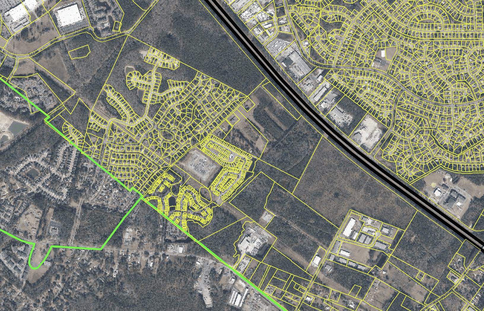
2. Read the Zoning Map Like a Developer
Pull up the county’s GIS zoning map (almost every county has this online and free). You’re looking for three specific situations:
Agricultural land surrounded by residential or commercial zoning – this parcel is an island of low-value zoning surrounded by higher-value uses. It’s almost certainly going to be rezoned eventually. The owner may not even know it’s sitting on a goldmine.
Land designated for future commercial or residential use on the comprehensive plan but still zoned agricultural, the comprehensive plan is the county’s official roadmap for growth. If it says “future residential” on a parcel that’s currently zoned agricultural, the gap between the current value and future value is your opportunity.
Large contiguous tracts near subdivision boundaries, when you see a 50-acre parcel with subdivisions on two or three sides of it, that parcel is surrounded by proof of demand. A developer can extend existing roads and utilities rather than building from scratch.
3. Chase the Utilities
Development follows infrastructure. No sewer, no dense development. Identify where the utility lines end and buy just ahead of them.
Specific moves:
- Call the local water and sewer authority and ask where their service area boundary is and whether there are any planned extensions. This is public information and utility employees will often tell you.
- Look at GIS maps for existing sewer and water lines. Land within 500 feet of an existing sewer line is dramatically more developable than land a mile away.
- Electric and telecom lines matter too but water/sewer is the real gate. Septic-dependent land has strict density limits, the moment public sewer arrives, density potential multiplies and land value follows.
4. Look for the Road Access Signals
Raw land with no road access is nearly worthless. Land with good road access, especially on a signalized intersection or a state-maintained road can be highly valuable.
Green flags:
- Frontage on a state-maintained road (the state maintains it, not the county, meaning higher traffic counts and better infrastructure)
- Corner lots at intersections – commercial developers especially value these
- Multiple points of access or the ability to connect to adjacent roads
- Proximity to a new or planned road extension
Red flags:
- Access only via a private easement across someone else’s land, this can be contested, blocked, or complicated
- Landlocked parcels with no recorded easement at all
- Frontage only on a dirt road with no plans for paving
5. Watch Building Permit Activity
When builders are pulling permits in an area, it’s the most concrete proof of developer demand you can find. This is public record.
- Go to the county building department’s website and look at recent permit activity by address or area
- If you see 5–10 new residential permits within a mile radius, builders are actively buying and developing that means your land would be in the same demand pool
- Look for commercial permits specifically a new Dollar General, Walmart, or fast food chain is a leading indicator that traffic counts and rooftop counts have crossed a threshold developers care about
6. Identify the “Last Raw Parcel” Syndrome
In fast-growing areas, as nearby parcels get developed one by one, the remaining raw parcels become more valuable simply because they’re scarce. A 30-acre raw tract surrounded by new subdivisions is extremely attractive to a builder who needs land and doesn’t want to wait years for entitlements on a greenfield site elsewhere.
Signs you’re looking at this situation:
- New subdivisions visible on satellite imagery that weren’t there 3–5 years ago (Google Earth’s historical imagery feature is invaluable here)
- New commercial development within a half mile
- The parcel has been in the same family for decades and was never sold during the surrounding development wave, the heirs may not know its current value
7. The Demographic Signals
Where people are moving, development follows. Track population and employment shifts.
What to watch:
- Metro areas with positive net migration (people moving in) consistently drive suburban and exurban land demand
- New employer announcements like a new Amazon fulfillment center, auto plant, or hospital campus creates immediate demand for housing and retail within a 20-mile radius
- School district quality: residential developers specifically target strong school districts because buyers follow them. A parcel in a highly rated school district commands a premium even if it’s currently raw land.
- University towns tend to have durable long-term demand because the institutional anchor never leaves
8. Use the Tools Available to You
Free or low-cost:
- County GIS portal: zoning, parcel boundaries, ownership, assessed value
- Google Earth historical imagery: see how an area has changed over 10–20 years
- State DOT long-range transportation plans: find planned road projects years in advance
- FEMA flood map service (msc.fema.gov): quickly screen out flood-prone parcels
- Census QuickFacts: population growth by county
Paid but powerful:
- CoStar or LoopNet: commercial real estate comps and development activity
- LandWatch or Lands of America: active land listings to understand pricing
- Regrid or Parcel Fabric: deep parcel data, ownership history, and acreage
The Mental Checklist
When you’re standing on or looking at a parcel, run through these five questions:
- Where is growth going and is this parcel in its path? If the answer isn’t clearly yes, move on.
- Can this parcel connect to public sewer and water within a reasonable cost? No sewer access kills most residential development density.
- Does the road access set a developer up to succeed? Poor access means a developer has to solve a problem before they can even start building.
- Is the zoning or comprehensive plan land use designation already aligned with development — or is it one step away? One step away is fine. Three steps away is too much risk.
- What has happened to the land within a half mile in the last five years? If the answer is “a lot,” you’re looking at a hot market. If the answer is “nothing,” find out why before assuming it’s an opportunity.
The best land investors train themselves to see the future land use of a parcel rather than its current use. A cow pasture is just a future subdivision that hasn’t been entitled yet.


Leave a Reply